


With displaced Los Angeles residents unable to return to their homes to assess the damage caused by the LA fires, new interactive maps surface. These maps give a much-needed glimpse into what awaits those evacuating: did their house make it? Or have they turned to ashes?
With 24 people dead because of the fires, residents are dreading another 72 hours of inhumane weather conditions, not knowing which direction the fires will take.
RELATED STORIES


The fire’s path of destruction
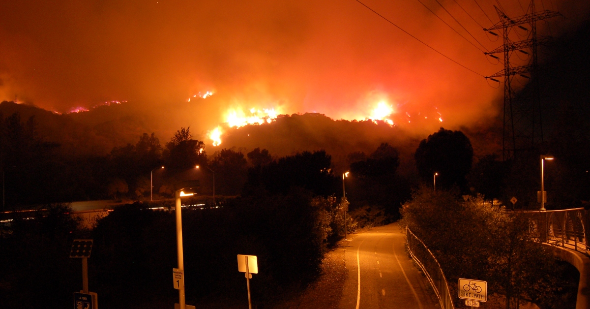
The fires have destroyed 40,000 acres and 12,300 structures across the wealthiest neighborhoods, engulfing A-list celebrity homes, and restaurant hotspots in its way, wiping them out.
The situation is so drastic that local fire departments warned those under mandatory evacuation orders not to return.
Cal Fire released a statement
According to Cal Fire, “Life-threatening winds and dangerously low humidity are forecast for much of Southern California creating a significant risk of rapid fire spread. The winds will cause increased fire activity.” Thus, locals are fearful of the roaring fires.
The locals resorted to the maps
Since the residents can’t access their homes post-evacuation, the maps opened a gate for them to assess the extent of the damage remotely without compromising their lives.
The map shows which structures have been destroyed, which have sustained some damage, and which have been spared.
What the colors mean

The handy map has colored the zones based on the need for evacuation. Orange means that fire is spreading in the area, red means that these areas are under evacuation order, and yellow areas mean that they have been issued an evacuation warning.
Other types of maps
Another map can show the status of your home. If your house is colored black, it means it is safe from the fires. If it is green, it means that your house sustained minor damage.
Orange, on the other hand, means that the house has been significantly damaged, and red means that the house has been destroyed beyond repair.
The fire spread is haphazard
The map strangely shows a red house amidst numerous black houses, which means that the red house was the only one destroyed in the area, with the others being untouched.
The map is always being updated; if a given address doesn’t have a mark, it means that it hasn’t been inspected yet.
50 shades of deadly
Officials warn against returning back to LA. The area is filled with asbestos ash and dangerous debris such as lead, arsenic, and other harmful materials.
In addition, the affected areas no longer have water or power, the gas lines there are broken, and the structures there are far from stable.
The Eaton fire is eating LA up
The Eaton fire has burned through 14,117 acres and about 7,000 structures. Moreover, 16 people were found dead in the rubble, with their identities still unknown.
The Eaton fire is now considered the fifth-deadliest fire on record in California. The fire is 27% contained, but the weather conditions may have another say.
The monstrosity of the Palisades fire
The Palisades fire is more catastrophic than Eaton, having burnt through 23,707 of prime southern California real estate, including the homes of A-list celebrities such as Miles Teller, Paris Hilton, and Mel Gibson.
The fire has spread from Pacific Palisades up to Malibu, destroying everything in between.
The next Hurricane Katrina
Former leader of the Federal Emergency Management Agency Craig Fugate likened the LA fires to Hurricane Katrina in New Orleans. He told the Los Angeles Times: “This is your Hurricane Katrina.”
He also said that the only difference between a flood and a fire is what it leaves behind. “With wildfires, there’s nothing left but ash. It’s almost like a total erasure of their history,” he said.
